
SolarAnywhere® Data
Precise, bankable solar irradiance data
SolarAnywhere is the most trusted, accurate & validated solar resource dataset available
- Reduce risk in selecting project locations and secure the best financing terms
- Model long-term energy production and financial performance with confidence
- Access the right dataset for your project—Typical GHI year, 25+ year historical time-series or site-adapted data

Features
Accurate
The most accurate and up-to-date satellite-derived solar resource data.
Validated & Trusted
Extensively validated and trusted by hundreds of enterprise-class customers with thousands of monthly downloads.
Data On Demand
Flexible delivery options include on-demand data and API access, with full records available (1998 – current day).
Bankability
SolarAnywhere exceeds the standards of bankability.
Advanced PV Modeling Data
Bifacial PV, high-resolution (30m) far-horizon shading, snow losses, soiling losses, surface albedo and more.
SolarAnywhere V4.0 Is Here
The latest version of the SolarAnywhere irradiance model brings some of our most significant improvements yet. Updates include the application of an advanced technique to correct geospatial image misalignment in Europe, the addition of dynamic water vapor as a model input and more.
Historical Data License Types
Sites
(Time Series)
Public
Historical Data License Comparison
Typical YearSee Pricing |
Typical Year+See Pricing |
SitesSee Pricing |
PublicGet Started |
|
|---|---|---|---|---|
| Data Types | ||||
| Average Year Summary |
 |
|
|
|
| Hourly TMY (8760) |
|
|
|
|
| Subhourly TMY |
|
|
|
|
| Time Series |
|
|
||
| Monthly Aggregations |
|
|
||
| Probability of Exceedance (PXX) |
|
|
||
| Details | ||||
| Data Version | V3.4 – V4.0 | V3.4 – V4.0 | V3.4 – V4.0 | V4.0 |
| Uncertainty | See SolarAnywhere Validation | See SolarAnywhere Validation | See SolarAnywhere Validation | See SolarAnywhere Validation |
| Global1 Datasets +/- 60 Degrees |
|
|
|
|
| High Latitude Data +/- 80 Degrees |
|
|||
| Time Period1 | 1998 – prior year | 1998 – prior year | 1998 – current hour | 1998 – current hour |
| Spatial Resolution | ||||
| Standard Spatial Resolution (10km) |
|
|
|
|
| Enhanced Spatial Resolution (1km) |
|
|
|
|
| High Spatial Resolution (500m) | Available with upgrade | Available at select locations | ||
| Temporal Resolution | ||||
| Hourly temporal resolution (1 hr) |
|
|
|
|
| Sub-hourly temporal resolution (30 min, 15 min) |
|
|
|
|
| Enhanced temporal resolution (5 min) | Available with upgrade | Available at select locations | ||
| License Access Term | 1 year | 1 year | 1 year | Free for limited (Public) locations |
| API Access | License tier dependent | License tier dependent | License tier dependent | N/A |
| Pricing | ||||
| Single Sites | $500 USD | N/A | Up to $2000 USD | Free for limited (Public) locations |
| Unlimited Data Portal Access | $11,000 USD | $15,500 USD | Contact Us | Free for limited (Public) locations |
| ePay Online |
|
|
|
N/A |
| Enterprise Agreements | Contact Us | Contact Us | Contact Us | N/A |
1See SolarAnywhere Geographic Coverage Area for more details.
Data Fields
Data Fields
Typical Year |
Typical Year+ |
Sites |
Public |
|
|---|---|---|---|---|
| Data Types | ||||
| GHI |
|
|
|
|
| DNI |
|
|
|
|
| DHI |
|
|
|
|
| Clear sky irradiance |
|
|
|
|
| Modeling (API & UI) | ||||
| Average plane-of-array irradiance (POAI) |
|
|
|
|
| Soiling losses |
|
|
|
|
| Snow losses |
|
|
|
|
| Modeling (API only) | ||||
| AC energy (kWh) |
|
|
|
|
| AC power (kW) |
|
|
|
|
| DC power (kW) |
|
|
|
|
| Clear sky power (kW) |
|
|
|
|
| Full PV System Modeling in API |
|
|
|
N/A |
| Time-series plane-of-array irradiance (POAI) |
|
|
||
| Fixed tilt, single-axis trackers, backtracking |
|
|
|
|
| Bifacial PV |
|
|
|
|
| Weather | ||||
| Temperature |
|
|
|
|
| Wind speed |
|
|
|
|
| Wind direction |
|
|
|
|
| Wind gust |
|
|
|
|
| Relative humidity |
|
|
|
|
| Precipitation |
|
|
||
| Particulate matter |
|
|
|
|
| Geography | ||||
| Elevation |
|
|
|
|
| Surface albedo |
|
|
|
|
| High-resolution (30m) far-horizon shading |
|
|
|
|
Customer Stories
Site-Adaptation Studies
Combine your ground-based measurements with SolarAnywhere® irradiance data to reduce the uncertainty of your solar resource assessments and increase project profitability.
SolarAnywhere Site-Adaptation (Ground-Tuning) Studies use an advanced site-adaptation methodology to tune long-term solar resource data to your ground-based measurements.

SolarAnywhere Data Resources

Blog

New SolarAnywhere® monitoring API (beta) joins across-the-board API performance enhancements
Clean Power Research® is excited to announce the public beta release of our new SolarAnywhere monitoring API, designed to provide you with scalable, seamless and efficient access to real-time data. This new, synchronous API supports fast and reliable data retrieval to...

Unlock the power of real-time solar data: New SolarAnywhere® dashboard
Clean Power Research® is excited to unlock the power of real-time solar data for more users with the launch of the SolarAnywhere® SystemCheck® Monitoring Dashboard. Users can now access and visualize SystemCheck real-time irradiance data directly from a user...

Enhancing precision with new SolarAnywhere® sub-hourly TMY data
Clean Power Research® is thrilled to announce the launch of SolarAnywhere® Sub-Hourly Typical Meteorological Year (TMY) irradiance and weather data! This feature provides SolarAnywhere customers with sub-hourly data, enhancing the precision of solar resource...
Frequently Asked Questions
Additional questions? Visit our FAQ page for more answers to commonly asked questions or contact us.
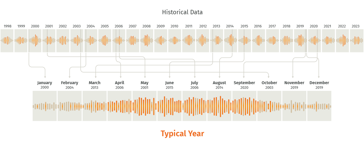
What is typical year?
Typical year is a year of hourly meteorological data for a specific location derived from years of historical time-series solar resource data. These data files are commonly used for solar resource availability assessments at potential project sites or running energy simulations to obtain P50 solar production estimates.
SolarAnywhere typical year data can be downloaded or requested as either a typical GHI year (TGY) or typical DNI year (TDY) file. These files contain a years’ worth of hourly observations (8760 hourly observations) selected with 100% weighting on either GHI or DNI. The files are generated for a specified location using the following two-step process:
-
- The long-term average monthly total irradiance is calculated for each month. The years considered in calculating the long-term averages is dependent upon the geographic data region:
- The actual months in the historic record with the monthly total irradiance values closest to the long-term averages calculated in step 1 are included in the TGY or TDY files.
- The long-term average monthly total irradiance is calculated for each month. The years considered in calculating the long-term averages is dependent upon the geographic data region:
The final TGY or TDY file will include 12 months of actual data from various years in the historical time series. For example, if January of 2010 has the monthly total irradiance closest to the long-term average monthly total irradiance for all Januarys as calculated in step 1, it will be included in the file. This is illustrated below.
To learn more about Typical Year data, visit our customer support center.
Why choose Typical Year+?
Watch this short video to learn about the SolarAnywhere Typical Year+ license, which enables access to Typical Year and Average Year Summary irradiance and weather data at the highest native spatial resolution available.
Reduce solar power forecast uncertainty with SolarAnywhere® Forecast
Solar forecasting solutions for the diverse needs of the solar power industry and utilities. SolarAnywhere Forecast is the solar industry’s leading irradiance forecast paired with trusted PV simulation.