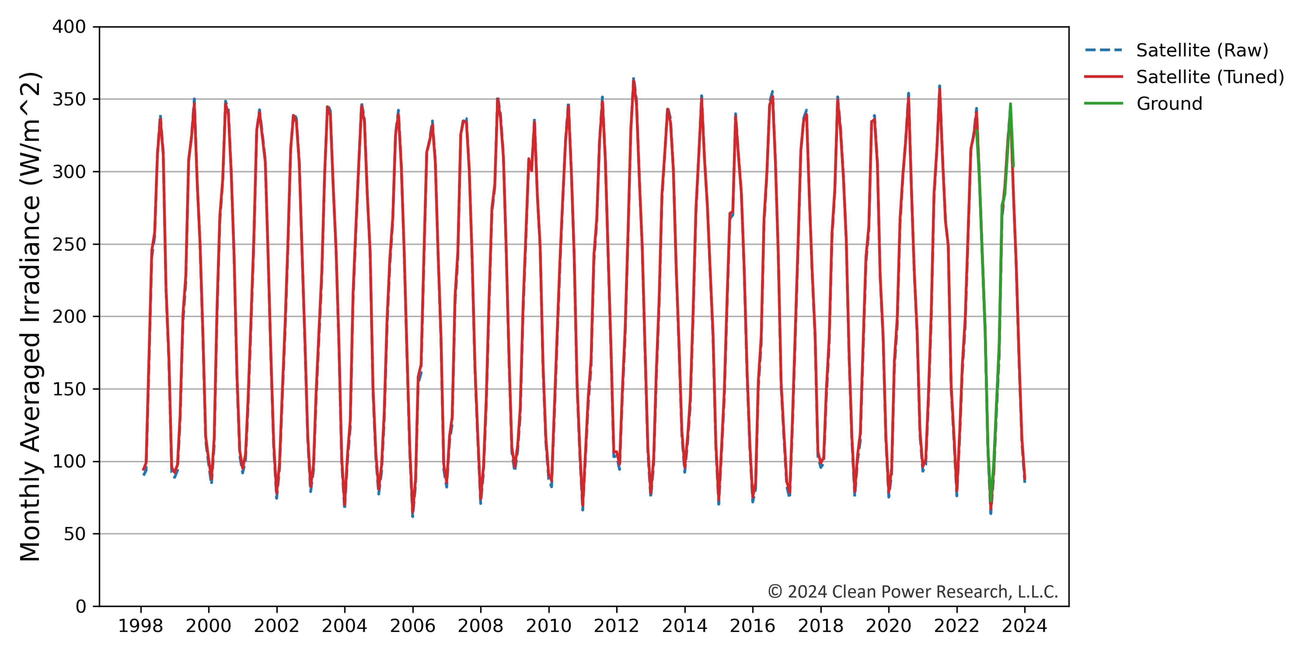
To minimize solar resource uncertainty and risk, SolarAnywhere® offers site-adaptation services to tune SolarAnywhere historical time-series data to high-quality ground-measured data. SolarAnywhere Site-Adaptation Studies (also known as Ground Tuning studies) use an advanced site-adaptation methodology to tune long-term solar resource data, spanning up to 27 years, to ground-based measurements.
Site-adaptation of satellite data to ground data
When performing pre-construction analysis at a new site, developers need to obtain high-quality solar resource data with known and reported uncertainty to quantify solar resource risk. Accurate solar resource data can be collected by installing on-site solar meteorological (MET) stations or downloaded on-demand through a commercial data provider like SolarAnywhere.
Commercial solar resource datasets are most often generated using satellite imagery collected by research organizations such as the National Oceanic and Atmospheric Administration (NOAA) or EUMETSAT. Site-adaptation methodologies were developed to combine these two independent sources of irradiance data to produce a dataset that takes advantage of the benefits of both.
To understand the long-term variability of the solar resource, a long history of irradiance and weather data is required. Satellite-based irradiance datasets like SolarAnywhere utilize archives of 27+ years of satellite imagery to provide this history. However, satellite-based models will always be limited to the available satellite image resolution and are therefore not able to capture the same precision as on-site MET stations. If a solar meteorological station is furnished with well-maintained, spectrally flat Class A pyranometers, the collected irradiance, temperature and wind data can result in highly accurate measurements with minimal uncertainty. However, ground measurement campaigns are most commonly conducted for 12- to 24-month periods due to development timelines and budgets.
SolarAnywhere offers a site-adaptation service to combine long-term satellite data to produce a low-uncertainty, long-term solar resource dataset. This combined dataset has lower uncertainty than using either the ground or satellite-based datasets on their own. Using SolarAnywhere satellite-based data and at least 12 months of ground measured reference data, it is possible to achieve a site-adapted data uncertainty as low as 1.2%.1
Satellite-Ground Site-Adaptation Methodology
To tune SolarAnywhere satellite irradiance data for a site-adaptation study, site-specific ground measurements of GHI, wind speed, and temperature are required. These are often collected over the course of one year by a trusted ground measurement installation and maintenance provider. SolarAnywhere then applies the following methodology to generate site-adapted data:
- Satellite-based irradiance data at an enhanced resolution (~ 1 km nominal) at the project site is generated.
- Ground measured data is quality controlled using methods available from the maintenance campaign provider and visual inspection by a trained SolarAnywhere data analyst.
- A seasonal correction is applied to the SolarAnywhere irradiance data to account for observed trends in clear sky conditions.
- Site adaptation tuning parameters are determined using the overlapping period of ground measurements and SolarAnywhere data. Since satellite and ground irradiance estimates exhibit different sources of error during clear sky conditions and cloudy conditions, an optimized tuning methodology determines unique tuning parameters for periods of cloudy and clear sky conditions for the project site.
- The tuning parameters are applied to the entire historical SolarAnywhere GHI dataset for the project site to produce a 60-minute resolution time series (1998-present).
- DNI and DHI components are rebalanced based on the tuned GHI data.
- The tuned and rebalanced time-series dataset is then used to generate typical GHI and typical DNI year datasets.
- A bias correction (relative to on-ground measurements) is applied to the satellite-derived wind and temperature data only if the bias for the study period exceeds pre-defined thresholds.

Figure 2. How long-term solar resource data can be tuned by ground data in order to reduce uncertainty across the entire dataset
Ground Data Measurement Best Practices
Ground irradiance measurement accuracy is reliant on instrument quality, frequency and effectiveness of maintenance, and calibration accuracy. For projects that are 10 MW or greater, solar developers typically deploy meteorological (MET) equipment once land acquisition is complete.
Measurement campaigns typically extend for at least one year. Many factors are considered to ensure data quality, including allowing access for proper maintenance, maintaining security of the station, and having the capability to log data for transmission back to servers. High-quality, well-maintained ground-measurement systems are required for achieving low uncertainty site-adapted data.
Clean Power Research partners with GroundWork Renewables to provide ground reference solar data for a turnkey solar resource assessment prior to construction for inputs into PV energy modeling. The quality of GroundWork’s ground datasets is quantified through published research and accompanying reports and metadata. Over sixty gigawatts of solar plants have used GroundWork’s high-quality ground data to get projects built. The revenue-grade measurement data is specifically designed to achieve Clean Power Research’s and our clients’ goals of reducing the uncertainty of the energy production forecast.
GroundWork datasets include global horizontal irradiance (GHI), PV soiling rates, albedo, diffuse horizontal irradiance (DHI), and other ancillary measurements and options. The cornerstone of GroundWork solar resource datasets is the GroundWatch Data Quality Program. By combining consistent onsite maintenance with meticulous daily quality control, GroundWatch datasets ensure high recovery and low disqualification rates for optimal use in site-adaptation studies.
Site-Adaptation Process
A site-adaptation study is typically completed in 10 business days. If the ground measurement campaign for your site is completed through GroundWork, then GroundWork provides Clean Power Research with high-quality ground data in the expected file format.
We highly recommend using a full year (12 months) of ground campaign data to be used for the tuning process to account for seasonal variability. A site-adaptation study can be completed with 9-12 months of data; however, we recommend completing a Data Refresh, once all 12 months of data are available. If a more recent SolarAnywhere data version has been released, a Data Update can also be performed to update tuned historical datasets using the latest data version.
If you are considering starting the ground data collection process for the first time through another ground campaign provider, please reach out to us to confirm necessary quality control and processes are in place. The team may require additional time to complete the site adaptation if ground measurements were collected through a provider other than GroundWork.
Upon receipt of complete, cleansed and properly formatted data files, the following deliverables are produced:
- A bankable solar resource assessment report that characterizes the solar resource and uncertainty for your project.
- Three data files that have been tuned to your ground measurements and compatible for import into all major PV design programs (like PVsyst, PlantPredict and RatedPower):
- 27+ Years of time-series (1998-present) at a standard resolution of 60-min, 1-km (also offered at a higher resolution of 15-min)
- Typical GHI Year
- Typical DNI Year
Request Site-Adaptation Services
Want to Learn more?
References
[1] K. Wagner, A. Kubiniec, T. McAlister and R. Perez, “The Importance of Data Quality for Reducing the Uncertainty of Site-Adapted Solar Resource Datasets,” 2023 IEEE 50th Photovoltaic Specialists Conference (PVSC), San Juan, PR, USA, 2023, pp. 1-5, doi: 10.1109/PVSC48320.2023.10360048.

